

Gratitude to:
- Captain Dimitar Stanishev (Mitko) for being our captain, friend, guide, keeper, and ...
- Sandra and D.A. for the permission to publish their photos on the Bozho's site
- Bozho for documenting the events and their presentation on this site
Participants
9 persons took part in the excursion:
- Common photos of the Participants
Accommodation
- hotel "Koloni", 4 km south of Volos town (20/21 June)
- The catamaran "Dances with waves" (21—28 June)
which was our sailing hotel and transportation vehicle during 21—28 June - hotel in Makrinitsa village (28/29 June)
Special photos
- Panorama photos from the excursion
Where we have roved?
The places we visited |
|
Towns/Cities
|
Villages
|
| Argo Saronic islands in the Saronic Gulf near Athens
|
Islands between the Saronic Gulf and the Argolic Gulf
Map of our sailing region 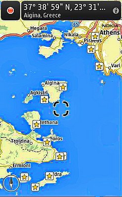
|
| Methana (Μέθανα) peninsula The volcanic Methana (Volcano) peninsula is attached to the Peloponnese (Πελοπόννησος) and contains 32 volcanoes, including the Methana volcano.
|
Roads - driving and sailing
|
20 June 2014 г.
21 June 2014 г.
- Nea Anchialos town
- road from Nea Anchialos town to Alimos marina in Athens city
- Alimos marina in Athens city
22 June 2014 г.
- sailing off Alimos marina in Athens city
- sailing from Alimos marina to Fleves island
- beach near Fleves island (Nisída Fléves, Νήσος Φλέβες, Νησίς Φλέβες (el), Φαβρα (grc), Νησίς Φλέβες, Φαβρα)
- Latitude 37.7678° = 37°46'12" N
Longitude: 23.7608° = 23°45'37" E
- Latitude 37.7678° = 37°46'12" N
- sailing form Fleves island to Poros island
- Poros village viewed from the sea
- evning walk in Poros village
- dinner in Poros village
23 June 2014 г.
- Port Porosс
- sailing off Poros town and Poros islnad
- sailing from Poros island to Skylli island
- beach near Skylli island (Nasis Skylli (Skyli, Σκυλλί) (Nisoi Tselevinia, Νησίδες Τσελεβίνια)
място: Бисиаика (Bisiaiika) в периферията на Атика (Attica)
- нашето котвено място:
Latitude: 37°26'20" N
Longitude: 23°32'28"
- нашето котвено място:
- sailing from Skylli island to Dokos island
- beach near Dokos island
- Latitude: 37°20'33.34" N
Longitude: 23°20'52.83" E - underwater and mear-the-water photos near Dokos island
- Latitude: 37°20'33.34" N
- walk on Dokos island
- evning near Dokos island
- Latitude: 37°20'33.34" N
Longitude: 23°20'52.83" E
- Latitude: 37°20'33.34" N
24 June 2014 г.
- morning near Dokos island
- sailing from Dokos island to a beach place near Hydra island
- beach near to Hydra island (Ύδρα [iðra])
- Latitude: 37°17'57" N
Longitude: 23°23'6" E - underwater and mear-the-water photos nea to Hydraisland
- Latitude: 37°17'57" N
- sailing north of Hydra siland
- Hydra town and port Hydra viewed from the sea
- walk in Hydra townd
- in Hydra port
- dinner in Hydra town
25 June 2014 г.
- sailing off Hydra town and Hydra island
- sailing from Hydra island to Spathi island
- beach between the Mainland and Spathi island (Nisis Spathi, Σπαθί)
- нашето котвено място:
Latitude: 37°26'6" N
Longitude: 23°31'22" E - underwater and mear-the-water photos around the whole Spathi island
- нашето котвено място:
- beach near the Mainland
- sailing from Spathi island to Methana peninsula
- arriving in Methana port and Methana town
- road to the Methana volcano
- excurssion on the Methana volcano
- starting point
Latitude: 37.6147600 N
Longitude: 23.3336000 E
- starting point
- walk from Methana volcano to Kameni Chora village
- dinner at tavern "OINOTHERAPEFTIRIO" ("ΟΙΝΟΘΕΡΑΠΕΥΤΗΡΙΟ", тел. +30 694 515 7323) in Kameni Chora village
- Latitude: 37°36'52.92" N
Longitude: 23°19'59.14" E
Elevation above sea level: 226 metres
- Latitude: 37°36'52.92" N
- port Methana and Methana town at night
26 June 2014 г.
- morning walk in Methana town
- sailing off Methana town and Methana peninsula
- sailing from Methana town to a beach near Moni island (Μονή) близо до село Пердика (Perdika, Πέρδικα) на остров Егина (Eginas, Αίγινας)
- beach near to Moni island
- sailing around Aegina island
- aproaching Agia Marina town on Aegina island
- night at the sea nea Agia Marina town on Aegina island
- Latitude: 37°44'44" N
Longitude: 23°32'35" E
- Latitude: 37°44'44" N
27 June 2014 г.
- morning at the sea near the Agia Marina town on Aegina island
- sailing from Aegina island to Idroisa island (Υδρουσα) near the Voula town ( Βούλα)
- beach near and around Idroisa island
- our anchor place:
Latitude: 37°50'16" N
Longitude: 23°44'49" E - underwater and mear-the-water photos around Idroisa island
- our anchor place:
- sailing from Idroisa island to Alimos marina in Athens
- night and dinner in Alimos marina in Athens
28 June 2014 г.
- driving along the streets of Athens
- Acropolis of Athens (Ακρόπολη Αθηνών))
- Parthenon site (Παρθενώνας)
- Ancient Agora of Athens (Αρχαία Αγορά της Αθήνας)
- random walks
- road from Athens city to Makrinitsa village
- from Athens to Karavomilos village (καραβομυλος)
- lunch stop in Karavomilos village
- Latitude: 38° 53' 12.16" N
Longitude: 22° 42' 16.33" E
- Latitude: 38° 53' 12.16" N
- from Karavomilos village to Volos town
- trough Volos town
- from Volos town to Makrinitsa village
- evning walk in Makrinitsa village
- dinner in Makrinitsa village
- Volos town at a glance at Evning
- Volos town at a glance at Night
29 June 2014 г.